
Make a donation
Gear up for your next adventure:
As an Amazon Associate, this site earns from qualifying purchases at no extra cost to you.
Byrnesville topographic map
Click on the map to display elevation.
Make a donation
Gear up for your next adventure:
As an Amazon Associate, this site earns from qualifying purchases at no extra cost to you.
About this map
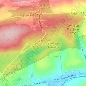
Name: Byrnesville topographic map, elevation, terrain.
Average elevation: 1,325 ft
Minimum elevation: 879 ft
Maximum elevation: 1,726 ft
Columbia County trails, hiking, mountain biking, running and outdoor activities
Make a donation
Gear up for your next adventure:
As an Amazon Associate, this site earns from qualifying purchases at no extra cost to you.
Other topographic maps
Click on a map to view its topography, its elevation and its terrain.
Locustdale
United States > Pennsylvania > Columbia County > Conyngham Township
Average elevation: 1,266 ft
Wilburton Number One
United States > Pennsylvania > Columbia County > Conyngham Township
Wilburton Number One is on the top of a mountain, at an elevation of 1,540 feet (470 m). Wilburton Number One's land is a mixture of forest and residential.
Average elevation: 1,440 ft