
Make a donation
Gear up for your next adventure:
As an Amazon Associate, this site earns from qualifying purchases at no extra cost to you.
Chapada Gaúcha topographic map
Click on the map to display elevation.
Make a donation
Gear up for your next adventure:
As an Amazon Associate, this site earns from qualifying purchases at no extra cost to you.
Chapada Gaúcha
Chapada Gaúcha is a municipality in the northern region of Minas Gerais, Brazil. The population in 2020 was 13,953 in an area of 3,215 km². The elevation of the municipal seat is 872 meters. It became a municipality in 1997. The postal code (CEP) is 39314-000.
Make a donation
Gear up for your next adventure:
As an Amazon Associate, this site earns from qualifying purchases at no extra cost to you.
About this map
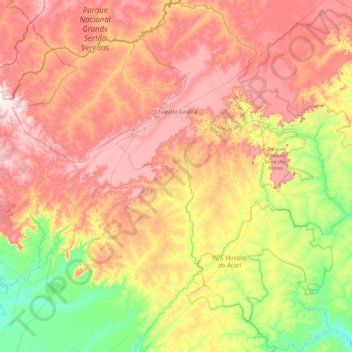
Name: Chapada Gaúcha topographic map, elevation, terrain.
Average elevation: 2,310 ft
Minimum elevation: 1,591 ft
Maximum elevation: 3,114 ft
Make a donation
Gear up for your next adventure:
As an Amazon Associate, this site earns from qualifying purchases at no extra cost to you.
Other topographic maps
Click on a map to view its topography, its elevation and its terrain.
Make a donation
Gear up for your next adventure:
As an Amazon Associate, this site earns from qualifying purchases at no extra cost to you.
Make a donation
Gear up for your next adventure:
As an Amazon Associate, this site earns from qualifying purchases at no extra cost to you.
Unaí
Brazil > Minas Gerais > Região Integrada de Desenvolvimento do Distrito Federal e Entorno > Unaí > Unaí
Average elevation: 1,939 ft
Belo Horizonte
Brazil > Minas Gerais > Região Metropolitana de Belo Horizonte > Belo Horizonte
In 1893, due to the climatic and topographic conditions, Curral Del Rey was selected by Minas Gerais governor Afonso Pena among other cities as the location for the new economic and cultural center of the state, under the new name of Cidade de Minas, or City of Minas.
Average elevation: 2,966 ft
Make a donation
Gear up for your next adventure:
As an Amazon Associate, this site earns from qualifying purchases at no extra cost to you.
São Vicente
Brazil > Minas Gerais > Região Integrada de Desenvolvimento do Distrito Federal e Entorno > Buritis > São Vicente
Average elevation: 2,116 ft