Springfield topographic map
Interactive map
Click on the map to display elevation.
About this map
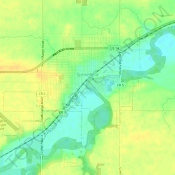
Name: Springfield topographic map, elevation, terrain.
Location: Springfield, Brown County, Minnesota, United States (44.22506 -95.00805 44.24721 -94.96201)
Average elevation: 1,053 ft
Minimum elevation: 1,004 ft
Maximum elevation: 1,089 ft
Other topographic maps
Click on a map to view its topography, its elevation and its terrain.
Sleepy Eye
United States > Minnesota > Brown County
Sleepy Eye, Brown County, Minnesota, United States
Average elevation: 1,017 ft
Hanska
United States > Minnesota > Brown County
Hanska, Brown County, Minnesota, United States
Average elevation: 1,010 ft
Evan
United States > Minnesota > Brown County
Evan, Brown County, Minnesota, United States
Average elevation: 1,027 ft
New Ulm
United States > Minnesota > Brown County
New Ulm, Brown County, Minnesota, 56073, United States
Average elevation: 912 ft
Cobden
United States > Minnesota > Brown County
Cobden, Brown County, Minnesota, United States
Average elevation: 1,027 ft
Comfrey
United States > Minnesota > Brown County
Comfrey, Brown County, Minnesota, United States
Average elevation: 1,129 ft