
Eidson topographic map
Click on the map to display elevation.
About this map
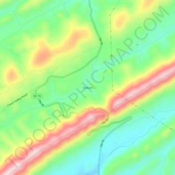
Name: Eidson topographic map, elevation, terrain.
Average elevation: 1,726 ft
Minimum elevation: 1,322 ft
Maximum elevation: 2,326 ft
Hawkins County trails, hiking, mountain biking, running and outdoor activities
Other topographic maps
Click on a map to view its topography, its elevation and its terrain.
Rogersville
United States > Tennessee > Hawkins County
Rogersville is located slightly southwest of the center of Hawkins County. According to the United States Census Bureau, the town has a total area of 3.4 square miles (8.8 km2), all land. The town is in the valley of Crockett Creek, a southwest-flowing tributary of the Holston River. The elevation of…
Average elevation: 1,365 ft