
Make a donation
Gear up for your next adventure:
As an Amazon Associate, this site earns from qualifying purchases at no extra cost to you.
Monte San Calogero topographic map
Click on the map to display elevation.
Make a donation
Gear up for your next adventure:
As an Amazon Associate, this site earns from qualifying purchases at no extra cost to you.
Monte San Calogero
Chiamato anche monte Kronio, perché secondo la leggenda questi era la dimora della divinità greca Crono (padre di Zeus), il complesso raggiunge un'altitudine di 395,48 m s.l.m. su un'area di 50 ettari ed è costituita prevalentemente da calcare.
Make a donation
Gear up for your next adventure:
As an Amazon Associate, this site earns from qualifying purchases at no extra cost to you.
About this map
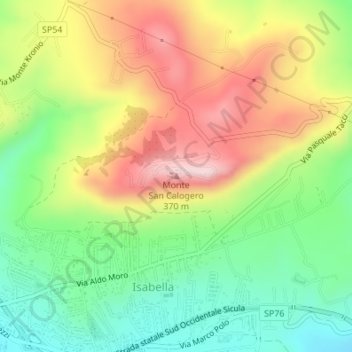
Name: Monte San Calogero topographic map, elevation, terrain.
Location: Monte San Calogero, Sciacca, Agrigento, Sicilia, 92019, Italia (37.51892 13.11433 37.51902 13.11443)
Average elevation: 610 ft
Minimum elevation: 89 ft
Maximum elevation: 1,260 ft
Make a donation
Gear up for your next adventure:
As an Amazon Associate, this site earns from qualifying purchases at no extra cost to you.