
Make a donation
Gear up for your next adventure:
As an Amazon Associate, this site earns from qualifying purchases at no extra cost to you.
San Gimignano topographic map
Click on the map to display elevation.
Make a donation
Gear up for your next adventure:
As an Amazon Associate, this site earns from qualifying purchases at no extra cost to you.
San Gimignano
The municipality of San Gimignano extends for 138 km² and is located on a hill in Val d'Elsa. The altitude difference is between a minimum of 64 meters a.s.l. in the plain of the river Elsa near Certaldo at a maximum of 631 meters in the area of Cornocchio.
Make a donation
Gear up for your next adventure:
As an Amazon Associate, this site earns from qualifying purchases at no extra cost to you.
About this map
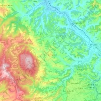
Name: San Gimignano topographic map, elevation, terrain.
Location: San Gimignano, Siena, Tuscany, Italy (43.40110 10.95083 43.54677 11.11317)
Average elevation: 784 ft
Minimum elevation: 210 ft
Maximum elevation: 2,060 ft
Make a donation
Gear up for your next adventure:
As an Amazon Associate, this site earns from qualifying purchases at no extra cost to you.
Other topographic maps
Click on a map to view its topography, its elevation and its terrain.