
Thank you for supporting this site ❤️
Make a donation
Make a donation
Gear up for your next adventure:
As an Amazon Associate, this site earns from qualifying purchases at no extra cost to you.
Sampaguita topographic map
Click on the map to display elevation.
Thank you for supporting this site ❤️
Make a donation
Make a donation
Gear up for your next adventure:
As an Amazon Associate, this site earns from qualifying purchases at no extra cost to you.
About this map
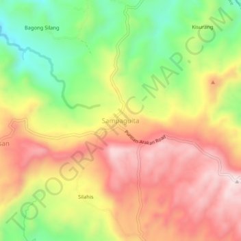
Name: Sampaguita topographic map, elevation, terrain.
Location: Sampaguita, Kibawe, Bukidnon, Northern Mindanao, Philippines (7.47580 125.04316 7.51580 125.08316)
Average elevation: 1,280 ft
Minimum elevation: 404 ft
Maximum elevation: 2,064 ft
Thank you for supporting this site ❤️
Make a donation
Make a donation
Gear up for your next adventure:
As an Amazon Associate, this site earns from qualifying purchases at no extra cost to you.