Geolocate

Wauchula topographic map

Click on the map to display elevation.

About this map

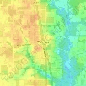
Name: Wauchula topographic map, elevation, terrain.

Location: Wauchula, Hardee County, Florida, 33873, United States (27.52743 -81.84205 27.56586 -81.77675)

Average elevation: 98 ft

Minimum elevation: 43 ft

Maximum elevation: 141 ft

Hardee County trails, hiking, mountain biking, running and outdoor activities

Other topographic maps

Click on a map to view its topography, its elevation and its terrain.

Lily

United States > Florida > Hardee County

Average elevation: 79 ft

Torrey

United States > Florida > Hardee County

Average elevation: 95 ft

Charlie Creek

United States > Florida > Hardee County

Average elevation: 79 ft

Gear up for your next adventure:

🪶Thermal Camp Blanket - Extra warmth for cold nights
🧴Hand Sanitizer - Keep hands clean while hiking
Backpacking Tents - Weight-optimized shelters for multi-day topographic surveys
🧭Compass with Lanyard - Easy‑carry compass for navigation
💧Water Purification System - Clean water on the trail with reliable purifiers

As an Amazon Associate, this site earns from qualifying purchases at no extra cost to you.