
Neustadt topographic map
Interactive map
Click on the map to display elevation.
About this map
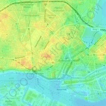
Name: Neustadt topographic map, elevation, terrain.
Location: Neustadt, Hamburg-Mitte, Hambourg, Allemagne (53.54055 9.96949 53.56105 9.99737)
Average elevation: 46 ft
Minimum elevation: -13 ft
Maximum elevation: 102 ft
Other topographic maps
Click on a map to view its topography, its elevation and its terrain.
Bahrenfeld
Allemagne > Hambourg > Hambourg
Bahrenfeld, Altona, Hambourg, 22761, Allemagne
Average elevation: 95 ft
Fuhlsbüttel
Allemagne > Hambourg > Hambourg
Fuhlsbüttel, Hamburg-Nord, Hambourg, Allemagne
Average elevation: 62 ft
Binnenalster
Allemagne > Hambourg > Hambourg
Binnenalster, Ballindamm, Hamburg-Altstadt, Hamburg-Mitte, Hambourg, 20095, Allemagne
Average elevation: 43 ft