
Make a donation
Gear up for your next adventure:
As an Amazon Associate, this site earns from qualifying purchases at no extra cost to you.
Gerlikon topographic map
Click on the map to display elevation.
Make a donation
Gear up for your next adventure:
As an Amazon Associate, this site earns from qualifying purchases at no extra cost to you.
Gerlikon
Gerlikon ist eine Ortschaft auf einer Anhöhe südwestlich von Frauenfeld im Kanton Thurgau. 1998 wurde Gerlikon in die Stadt Frauenfeld eingemeindet. Vorher war Gerlikon als Ortsgemeinde Teil der damaligen Munizipalgemeinde Gachnang.
Make a donation
Gear up for your next adventure:
As an Amazon Associate, this site earns from qualifying purchases at no extra cost to you.
About this map
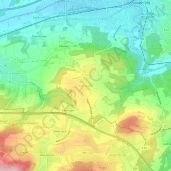
Name: Gerlikon topographic map, elevation, terrain.
Average elevation: 1,624 ft
Minimum elevation: 1,309 ft
Maximum elevation: 2,152 ft
Make a donation
Gear up for your next adventure:
As an Amazon Associate, this site earns from qualifying purchases at no extra cost to you.