Geolocate

Felmersham topographic map

Click on the map to display elevation.

About this map

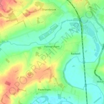
Name: Felmersham topographic map, elevation, terrain.

Location: Felmersham, Bedford, England, United Kingdom (52.19224 -0.58824 52.22068 -0.51233)

Average elevation: 187 ft

Minimum elevation: 102 ft

Maximum elevation: 331 ft

Gear up for your next adventure:

🪑Portable Camp Table - Compact table for campsite meals
🎒Day Hiking Backpack - Lightweight backpack perfect for day trips and outdoor adventures
🎒Outdoor Daypacks - Lightweight backpacks designed for carrying maps and essential gear
🔦Compact Flashlight - Reliable flashlight for emergencies
🥾Hiking Shoes - Durable and comfortable shoes for trail hiking

As an Amazon Associate, this site earns from qualifying purchases at no extra cost to you.