Geolocate

Cherry Valley topographic map

Click on the map to display elevation.

Cherry Valley

With an elevation of 2,980 feet above sea level, Cherry Valley is at the highest point on the San Gorgonio Pass between San Bernardino and Palm Springs. According to the United States Census Bureau, the CDP has a total area of 8.1 square miles (21 km2), all of it land.

Wikipedia (CC-BY-SA 3.0)

About this map

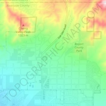
Name: Cherry Valley topographic map, elevation, terrain.

Location: Cherry Valley, Beaumont, Riverside County, California, United States (33.95432 -117.00110 34.00482 -116.93793)

Average elevation: 3,091 ft

Minimum elevation: 2,562 ft

Maximum elevation: 4,331 ft

Gear up for your next adventure:

🪶LED Camping Lantern - Bright lantern for camp lighting
🔪Outdoor Multitools - Essential survival tools for gear repair and field use
🧦Hiking Socks - Comfortable socks to prevent blisters on long hikes
📱Solar Portable Charger - Solar power bank for charging devices off‑grid
🌐World Map Poster - Decorative world maps with topographic info

As an Amazon Associate, this site earns from qualifying purchases at no extra cost to you.