
Make a donation
Gear up for your next adventure:
As an Amazon Associate, this site earns from qualifying purchases at no extra cost to you.
Carrara topographic map
Click on the map to display elevation.
Make a donation
Gear up for your next adventure:
As an Amazon Associate, this site earns from qualifying purchases at no extra cost to you.
About this map
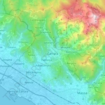
Name: Carrara topographic map, elevation, terrain.
Location: Carrara, Massa-Carrara, Tuscany, 54033, Italy (44.02666 10.01876 44.12975 10.17111)
Average elevation: 1,237 ft
Minimum elevation: -3 ft
Maximum elevation: 5,627 ft
Make a donation
Gear up for your next adventure:
As an Amazon Associate, this site earns from qualifying purchases at no extra cost to you.
Other topographic maps
Click on a map to view its topography, its elevation and its terrain.
Make a donation
Gear up for your next adventure:
As an Amazon Associate, this site earns from qualifying purchases at no extra cost to you.
Monte Citerna
Italy > Tuscany > Metropolitan City of Florence > Barberino di Mugello
Average elevation: 2,405 ft