Geolocate

Sairme topographic map

Click on the map to display elevation.

About this map

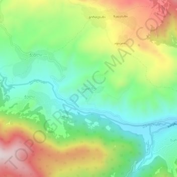
Name: Sairme topographic map, elevation, terrain.

Location: Sairme, Adigeni Municipality, Samtskhe-Javakheti, Georgia (41.67161 42.60692 41.71161 42.64692)

Average elevation: 4,665 ft

Minimum elevation: 3,875 ft

Maximum elevation: 5,928 ft

Gear up for your next adventure:

🧯Portable Fire Pit - Compact fire pit for camping spots
🛡️Bear Spray Outdoor - Protection in bear country hikes
👟Men's Trail Runners - Lightweight footwear for fast-paced exploration and light hiking
🪶Compact Camp Shovel - Folding shovel for campsite tasks
🏕️Family Camping Gear - Essentials for group camping trips

As an Amazon Associate, this site earns from qualifying purchases at no extra cost to you.