Geolocate

Beacon topographic map

Click on the map to display elevation.

About this map

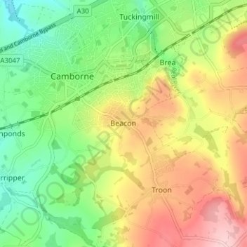
Name: Beacon topographic map, elevation, terrain.

Location: Beacon, Camborne, Cornwall, England, TR14 7SE, United Kingdom (50.18622 -5.30611 50.22622 -5.26611)

Average elevation: 410 ft

Minimum elevation: 144 ft

Maximum elevation: 751 ft

Gear up for your next adventure:

🪶Fire Starter Kit - Reliable fire starter for survival and camping
🏫Relief Map Kits - Hands-on tools for teaching landforms and elevation
🔦LED Headlamp - Bright and durable LED headlamp for night navigation
🌧️Backpack Rain Cover - Keep gear dry in wet weather
📦Dry Bags Set - Waterproof storage for electronics and clothes

As an Amazon Associate, this site earns from qualifying purchases at no extra cost to you.