
Make a donation
Gear up for your next adventure:
As an Amazon Associate, this site earns from qualifying purchases at no extra cost to you.
Fustiñana topographic map
Click on the map to display elevation.
Make a donation
Gear up for your next adventure:
As an Amazon Associate, this site earns from qualifying purchases at no extra cost to you.
Fustiñana
La villa de Fustiñana se encuentra situada al sur de la Comunidad Foral de Navarra en la región geográfica de la Ribera de Navarra a una altitud de 258 m s. n. m. Su término municipal tiene una superficie de 67,1 km² y limita al norte y este con las Bardenas Reales, al sur con Buñuel y al oeste con Ribaforada y Cabanillas.
Make a donation
Gear up for your next adventure:
As an Amazon Associate, this site earns from qualifying purchases at no extra cost to you.
About this map
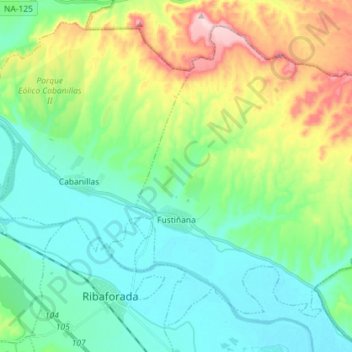
Name: Fustiñana topographic map, elevation, terrain.
Location: Fustiñana, Ribera, Navarra, 31510, España (41.98898 -1.51371 42.07990 -1.37062)
Average elevation: 1,024 ft
Minimum elevation: 771 ft
Maximum elevation: 1,673 ft
Make a donation
Gear up for your next adventure:
As an Amazon Associate, this site earns from qualifying purchases at no extra cost to you.
Other topographic maps
Click on a map to view its topography, its elevation and its terrain.