Geolocate

Toano topographic map

Click on the map to display elevation.

About this map

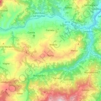
Name: Toano topographic map, elevation, terrain.

Location: Toano, Appennino Reggiano, Reggio nell'Emilia, Emilia-Romagna, Italy (44.34346 10.47131 44.42024 10.62445)

Average elevation: 1,952 ft

Minimum elevation: 817 ft

Maximum elevation: 3,999 ft

Other topographic maps

Click on a map to view its topography, its elevation and its terrain.

Cornacchia

Italy > Emilia-Romagna > Reggio nell'Emilia > Barcaccia

Average elevation: 436 ft

Monzone

Italy > Emilia-Romagna > Reggio nell'Emilia

Average elevation: 2,224 ft

Veggia

Italy > Emilia-Romagna > Reggio nell'Emilia > Casalgrande

Average elevation: 449 ft

Carezza

Italy > Emilia-Romagna > Reggio nell'Emilia > Pantano

Average elevation: 2,031 ft

Cerreto Laghi

Italy > Emilia-Romagna > Reggio nell'Emilia

Average elevation: 4,331 ft

Bonzano

Italy > Emilia-Romagna > Reggio nell'Emilia > Poiago > Bonzano

Average elevation: 1,932 ft

Gear up for your next adventure:

🛡️Insect Repellent - Protection against bugs during outdoor activities
🧭Orienteering Set - Complete compass and map reading kit
🚗GPS Dash Cams - Record your scenic drives through mountain passes and canyons
📦Dry Bags Set - Waterproof storage for electronics and clothes
Camping Coffee Makers - Enjoy premium coffee at the summit or campsite

As an Amazon Associate, this site earns from qualifying purchases at no extra cost to you.