
Portland topographic map
Click on the map to display elevation.
Portland
Der Washington Park hat eine Fläche von 52,41 Hektar und befindet sich auf einer Anhöhe (61 bis 265 m). Er umfasst unter anderem den Oregon Zoo mit 200 Arten, einen Japanischen Garten mit einer Größe von 22.000 m², das 1928 gegründete Hoyt Arboretum mit 10.000 Bäumen, ein Kindermuseum sowie den Waldlehrpfad World Forestry Center (seit 1906). Des Weiteren gibt es eine Vielzahl an Monumenten, Brunnen und Gedenktafeln.
About this map
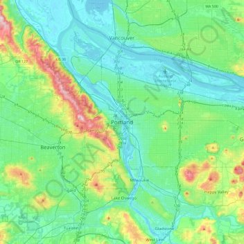
Name: Portland topographic map, elevation, terrain.
Average elevation: 262 ft
Minimum elevation: -13 ft
Maximum elevation: 1,257 ft