Geolocate

Marta topographic map

Click on the map to display elevation.

About this map

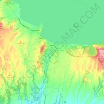
Name: Marta topographic map, elevation, terrain.

Location: Marta, Viterbo, Lazio, Italy (42.48375 11.89153 42.57222 11.96657)

Average elevation: 1,083 ft

Minimum elevation: 860 ft

Maximum elevation: 1,535 ft

Other topographic maps

Click on a map to view its topography, its elevation and its terrain.

Monte Raschio

Italy > Lazio > Viterbo > Oriolo Romano

Average elevation: 1,470 ft

Bagnaia

Italy > Lazio > Viterbo > Viterbo

Average elevation: 1,522 ft

Isola Bisentina

Italy > Lazio > Viterbo > Capodimonte

Average elevation: 997 ft

Cura

Italy > Lazio > Viterbo > Vetralla

Average elevation: 1,289 ft

Gear up for your next adventure:

🏔️Mountain Trail Maps - High‑detail maps for popular peaks
🥩Freeze-Dried Meals - Nutritious and lightweight food for remote expeditions
🧼Biodegradable Camping Soap - Eco‑friendly soap for outdoor hygiene
📦Dry Bags Set - Waterproof storage for electronics and clothes
🧣Hiking Neck Gaiter - Multi‑use neck protection for outdoor weather

As an Amazon Associate, this site earns from qualifying purchases at no extra cost to you.