Geolocate

Bilog topographic map

Click on the map to display elevation.

About this map

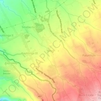
Name: Bilog topographic map, elevation, terrain.

Location: Bilog, Alfonso, Cavite, Calabarzon, 4123, Philippines (14.08111 120.81969 14.12111 120.85969)

Average elevation: 1,549 ft

Minimum elevation: 1,148 ft

Maximum elevation: 1,880 ft

Other topographic maps

Click on a map to view its topography, its elevation and its terrain.

Amuyong

Philippines > Cavite > Alfonso

Average elevation: 1,781 ft

Amuyong

Philippines > Cavite > Alfonso

Average elevation: 1,781 ft

Gear up for your next adventure:

🏥Hiking First Aid Kits - Comprehensive medical kits for remote trail injuries
🎒Outdoor Daypacks - Lightweight backpacks designed for carrying maps and essential gear
🥾Women's Hiking Boots - Top-rated trail boots with ankle support and superior grip
🗺️NatGeo Topo Maps - High-quality waterproof printed topographic maps of US Parks
🥇GPS Hiking Watch - Multi‑sport GPS watch with navigation and trail tracking

As an Amazon Associate, this site earns from qualifying purchases at no extra cost to you.