
Make a donation
Gear up for your next adventure:
As an Amazon Associate, this site earns from qualifying purchases at no extra cost to you.
Luquina Chico topographic map
Click on the map to display elevation.
Make a donation
Gear up for your next adventure:
As an Amazon Associate, this site earns from qualifying purchases at no extra cost to you.
About this map
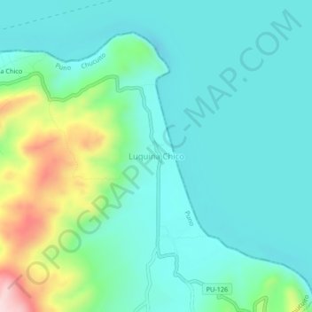
Name: Luquina Chico topographic map, elevation, terrain.
Location: Luquina Chico, Chucuito, Province of Puno, Puno, Peru (-15.81931 -69.82284 -15.77931 -69.78284)
Average elevation: 12,680 ft
Minimum elevation: 12,434 ft
Maximum elevation: 13,527 ft
Make a donation
Gear up for your next adventure:
As an Amazon Associate, this site earns from qualifying purchases at no extra cost to you.
Other topographic maps
Click on a map to view its topography, its elevation and its terrain.
Lake Titicaca
Lake Titicaca has a surface elevation of 3,812 m (12,507 ft). The "highest lake" claim is generally considered to refer to commercial craft. Numerous smaller bodies of water (that are not considered lakes) around the world are at higher elevations. For many years, the largest vessel afloat on the lake was the…
Average elevation: 12,697 ft
Province of Chucuito
One of the highest elevations of the province is Chuqi Patilla at approximately 5,200 m (17,100 ft). Other mountains are listed below.
Average elevation: 13,291 ft
Make a donation
Gear up for your next adventure:
As an Amazon Associate, this site earns from qualifying purchases at no extra cost to you.
Make a donation
Gear up for your next adventure:
As an Amazon Associate, this site earns from qualifying purchases at no extra cost to you.