
Make a donation
Gear up for your next adventure:
As an Amazon Associate, this site earns from qualifying purchases at no extra cost to you.
Schmehausen topographic map
Click on the map to display elevation.
Make a donation
Gear up for your next adventure:
As an Amazon Associate, this site earns from qualifying purchases at no extra cost to you.
About this map
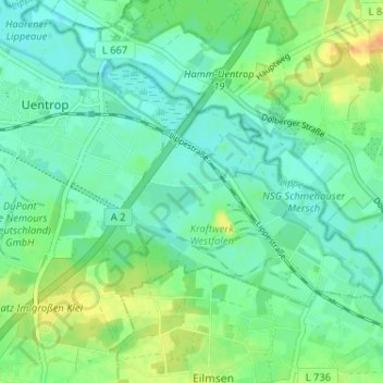
Name: Schmehausen topographic map, elevation, terrain.
Location: Schmehausen, Uentrop, Hamm, Nordrhein-Westfalen, Deutschland (51.66348 7.94525 51.70348 7.98525)
Average elevation: 230 ft
Minimum elevation: 194 ft
Maximum elevation: 299 ft
Make a donation
Gear up for your next adventure:
As an Amazon Associate, this site earns from qualifying purchases at no extra cost to you.
Other topographic maps
Click on a map to view its topography, its elevation and its terrain.
Bockum-Hövel
Deutschland > Nordrhein-Westfalen > Hamm
Die Koordinaten für die zentrale Ortslage beziehen sich auf das frühere Rathaus, den heutigen Sitz der Bezirksvertretung. Auf diese Koordinaten ist auch die Höhenangabe zu beziehen: 65,53 m ü. NN. Laut dem Statistischen Jahrbuch der Stadt Hamm 2005 befindet sich die höchste natürliche Erhebung im…
Average elevation: 253 ft
Make a donation
Gear up for your next adventure:
As an Amazon Associate, this site earns from qualifying purchases at no extra cost to you.