
Port Royal topographic map
Click on the map to display elevation.
About this map
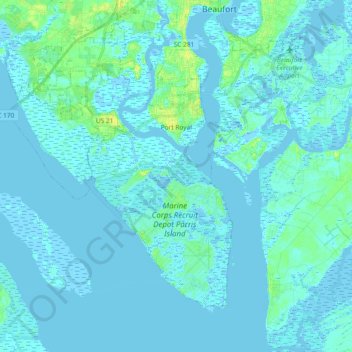
Name: Port Royal topographic map, elevation, terrain.
Location: Port Royal, Beaufort County, South Carolina, United States (32.29880 -80.84387 32.41520 -80.65823)
Average elevation: 7 ft
Minimum elevation: -13 ft
Maximum elevation: 56 ft
Beaufort County trails, hiking, mountain biking, running and outdoor activities
Other topographic maps
Click on a map to view its topography, its elevation and its terrain.
Royal Pines Country Club Estates
United States > South Carolina > Beaufort County
Average elevation: 23 ft
Hilton Head Plantation
United States > South Carolina > Beaufort County > Hilton Head Island
Average elevation: 20 ft
Palmetto Dunes
United States > South Carolina > Beaufort County > Hilton Head Island
Average elevation: 10 ft
Hilton Head Island
United States > South Carolina > Beaufort County > Hilton Head Island
Average elevation: 7 ft
Sea Pines
United States > South Carolina > Beaufort County > Hilton Head Island
Average elevation: 13 ft
Palmetto Dunes
United States > South Carolina > Beaufort County > Hilton Head Island
Average elevation: 10 ft
Coligny
United States > South Carolina > Beaufort County > Hilton Head Island
Average elevation: 10 ft
Port Royal
United States > South Carolina > Beaufort County > Hilton Head Island
Average elevation: 10 ft
Indigo Run
United States > South Carolina > Beaufort County > Hilton Head Island
Average elevation: 16 ft
Morgan River Estates
United States > South Carolina > Beaufort County > Morgan River Estates
Average elevation: 13 ft
Hilton Head Plantation
United States > South Carolina > Beaufort County > Hilton Head Island
Average elevation: 20 ft