Geolocate

Moonak topographic map

Click on the map to display elevation.

About this map

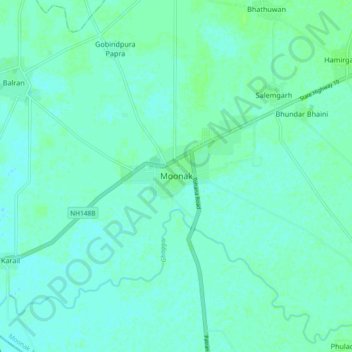
Name: Moonak topographic map, elevation, terrain.

Location: Moonak, Moonak Tahsil, Sangrur District, Punjab, India (29.78009 75.85124 29.86009 75.93124)

Average elevation: 738 ft

Minimum elevation: 728 ft

Maximum elevation: 751 ft

Gear up for your next adventure:

🔥Fast-Boil Camping Stoves - Efficient cooking systems for quick trail meals
🚁Photography Drones - Capture stunning aerial views of landforms and topography
🧷Carabiner Set - Durable clips for gear attachment
👟Men's Trail Runners - Lightweight footwear for fast-paced exploration and light hiking
🌐World Map Poster - Decorative world maps with topographic info

As an Amazon Associate, this site earns from qualifying purchases at no extra cost to you.