
Make a donation
Gear up for your next adventure:
As an Amazon Associate, this site earns from qualifying purchases at no extra cost to you.
Shahin Shahr topographic map
Click on the map to display elevation.
Make a donation
Gear up for your next adventure:
As an Amazon Associate, this site earns from qualifying purchases at no extra cost to you.
Shahin Shahr
The city is among the central mountain ranges of Iran to the east of the Zagros Mountains. It has an altitude of 1662 meters on average with a slope of 16%. It has a dry climate with very little precipitation. The variation in temperature is about 50 degrees Celsius.
Make a donation
Gear up for your next adventure:
As an Amazon Associate, this site earns from qualifying purchases at no extra cost to you.
About this map
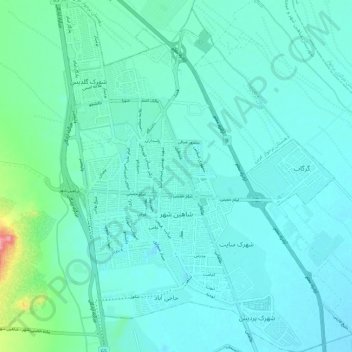
Name: Shahin Shahr topographic map, elevation, terrain.
Average elevation: 5,253 ft
Minimum elevation: 5,194 ft
Maximum elevation: 5,607 ft
Make a donation
Gear up for your next adventure:
As an Amazon Associate, this site earns from qualifying purchases at no extra cost to you.
Other topographic maps
Click on a map to view its topography, its elevation and its terrain.
Muteh
Iran > Isfahan Province > Shahin Shahr and Meymeh County > Zarkan RD
Average elevation: 6,302 ft
Murchehkhort
Iran > Isfahan Province > Shahin Shahr and Meymeh County > دهستان مورچه خورت > Murchehkhort
Average elevation: 5,492 ft