Geolocate

Turi topographic map

Click on the map to display elevation.

About this map

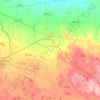
Name: Turi topographic map, elevation, terrain.

Location: Turi, Bari, Apulia, Italy (40.84545 16.96011 40.95838 17.06216)

Average elevation: 863 ft

Minimum elevation: 584 ft

Maximum elevation: 1,152 ft

Other topographic maps

Click on a map to view its topography, its elevation and its terrain.

Altamura

Italy > Apulia > Bari > Altamura

Average elevation: 1,342 ft

Polignano a Mare

Italy > Apulia > Bari

Average elevation: 138 ft

Monte Belvedere

Italy > Apulia > Bari > Altamura

Average elevation: 1,496 ft

Gear up for your next adventure:

🧭Pro Hiking Compasses - High-accuracy liquid-filled compasses for topographic orientation
🪶Wildlife Field Guides - Learn animal tracking and species ID
📷Action Camera - Capture your outdoor adventures in HD
👖Convertible Hiking Pants - Versatile zip-off pants for changing altitudes and temperatures
🎒Day Hiking Backpack - Lightweight backpack perfect for day trips and outdoor adventures

As an Amazon Associate, this site earns from qualifying purchases at no extra cost to you.