Geolocate

Aqaba topographic map

Click on the map to display elevation.

About this map

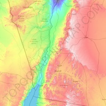
Name: Aqaba topographic map, elevation, terrain.

Location: Aqaba, Jordan (29.23799 34.88444 30.71037 35.73710)

Average elevation: 2,457 ft

Minimum elevation: -430 ft

Maximum elevation: 5,853 ft

Other topographic maps

Click on a map to view its topography, its elevation and its terrain.

Petra

Jordan > Aqaba > Wadi Araba Sub-District

Average elevation: 2,211 ft

Finan

Jordan > Aqaba > Wadi Araba Sub-District

Average elevation: -138 ft

Al Qurayqarah

Jordan > Aqaba > Wadi Araba Sub-District

Average elevation: 361 ft

Gear up for your next adventure:

🕶️GPS Smartphone Mount - Secure mount for phone navigation
Solar GPS Watches - Advanced multisport watches with built-in topographic maps
🪶Wildlife Field Guides - Learn animal tracking and species ID
🌡️Portable Weather Meter - Track weather conditions on the trail
💧Water Purification System - Clean water on the trail with reliable purifiers

As an Amazon Associate, this site earns from qualifying purchases at no extra cost to you.