
Make a donation
Gear up for your next adventure:
As an Amazon Associate, this site earns from qualifying purchases at no extra cost to you.
Stakčín topographic map
Click on the map to display elevation.
Make a donation
Gear up for your next adventure:
As an Amazon Associate, this site earns from qualifying purchases at no extra cost to you.
Stakčín
The municipality lies in the Cirocha river valley, at an altitude of 257 metres and with a total area of 167.742 km2. According to the 2013 census it had a population of 2452 inhabitants. It lies between the Vihorlat and Bukovské vrchy mountains. The municipality is the seat of the Poloniny National Park governing body.
Make a donation
Gear up for your next adventure:
As an Amazon Associate, this site earns from qualifying purchases at no extra cost to you.
About this map
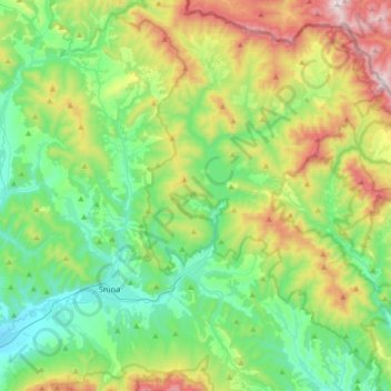
Name: Stakčín topographic map, elevation, terrain.
Average elevation: 1,545 ft
Minimum elevation: 594 ft
Maximum elevation: 3,763 ft
Make a donation
Gear up for your next adventure:
As an Amazon Associate, this site earns from qualifying purchases at no extra cost to you.