
Make a donation
Gear up for your next adventure:
As an Amazon Associate, this site earns from qualifying purchases at no extra cost to you.
Huangpu District topographic map
Click on the map to display elevation.
Make a donation
Gear up for your next adventure:
As an Amazon Associate, this site earns from qualifying purchases at no extra cost to you.
Huangpu District
The district is pioneering in the low-altitude economy, which includes the development of aerial innovations. Notably, EHang Holdings, based in Huangpu, received the first certification for manned eVTOL (electric vertical take-off and landing) aircraft, positioning the district at the forefront of the urban aerial transportation sector. Huangpu is actively integrating low-altitude economic activities with urban management and tourism, and the district boasts 45 enterprises involved in the low-altitude industrial chain.
Make a donation
Gear up for your next adventure:
As an Amazon Associate, this site earns from qualifying purchases at no extra cost to you.
About this map
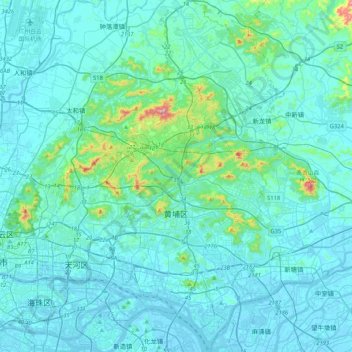
Name: Huangpu District topographic map, elevation, terrain.
Location: Huangpu District, Guangzhou City, Guangdong Province, China (23.03108 113.39248 23.41549 113.60407)
Average elevation: 148 ft
Minimum elevation: -30 ft
Maximum elevation: 1,663 ft
Make a donation
Gear up for your next adventure:
As an Amazon Associate, this site earns from qualifying purchases at no extra cost to you.
Other topographic maps
Click on a map to view its topography, its elevation and its terrain.