Geolocate

Bhankoli topographic map

Click on the map to display elevation.

About this map

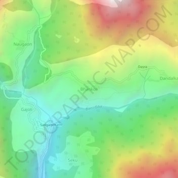
Name: Bhankoli topographic map, elevation, terrain.

Location: Bhankoli, Bhatwari, Uttarkashi, Uttarakhand, India (30.82390 78.44063 30.86390 78.48063)

Average elevation: 7,188 ft

Minimum elevation: 4,911 ft

Maximum elevation: 11,020 ft

Other topographic maps

Click on a map to view its topography, its elevation and its terrain.

Kyarkoti Lake

India > Uttarakhand > Bhatwari

Average elevation: 13,264 ft

Harsil

India > Uttarakhand > Bhatwari

Average elevation: 9,058 ft

Pari Maatri Taal

India > Uttarakhand > Bhatwari

Average elevation: 14,577 ft

Kedar Tal

India > Uttarakhand > Bhatwari

Average elevation: 15,794 ft

Dayara Bugyal

India > Uttarakhand > Bhatwari

Average elevation: 11,322 ft

Harsil

India > Uttarakhand > Bhatwari

Average elevation: 9,058 ft

Kalindi Khal Area

India > Uttarakhand > Bhatwari

Average elevation: 19,216 ft

Gangotri Glacier

India > Uttarakhand > Bhatwari

Average elevation: 17,254 ft

Kedar Tal

India > Uttarakhand > Bhatwari

Average elevation: 15,794 ft

Gangotri Glacier

India > Uttarakhand > Bhatwari

Average elevation: 17,254 ft

Gear up for your next adventure:

🦺Reflective Outdoor Gear - Safety gear for low‑light conditions
👟Trail Running Shoes - Lightweight shoes for trail runners
🗺️NatGeo Topo Maps - High-quality waterproof printed topographic maps of US Parks
Backpacking Tents - Weight-optimized shelters for multi-day topographic surveys
🎒Day Hiking Backpack - Lightweight backpack perfect for day trips and outdoor adventures

As an Amazon Associate, this site earns from qualifying purchases at no extra cost to you.