
Thank you for supporting this site ❤️
Make a donation
Make a donation
Gear up for your next adventure:
As an Amazon Associate, this site earns from qualifying purchases at no extra cost to you.
Sitges topographic map
Click on the map to display elevation.
Thank you for supporting this site ❤️
Make a donation
Make a donation
Gear up for your next adventure:
As an Amazon Associate, this site earns from qualifying purchases at no extra cost to you.
About this map
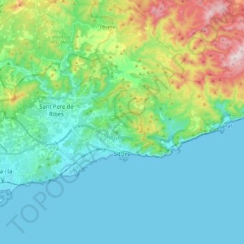
Name: Sitges topographic map, elevation, terrain.
Location: Sitges, Garraf, Barcelona, Catalonia, Spain (41.21859 1.75620 41.29101 1.94455)
Average elevation: 427 ft
Minimum elevation: -3 ft
Maximum elevation: 1,939 ft
Thank you for supporting this site ❤️
Make a donation
Make a donation
Gear up for your next adventure:
As an Amazon Associate, this site earns from qualifying purchases at no extra cost to you.