Geolocate

Oberstenfeld topographic map

Click on the map to display elevation.

Oberstenfeld

Prevorst is an exclave located between the Heilbronn district and the Rems-Murr district. With an elevation of 482m it is the highest location of the Ludwigsburg district.

Wikipedia (CC-BY-SA 3.0)

About this map

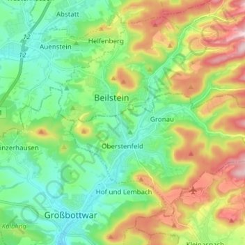
Name: Oberstenfeld topographic map, elevation, terrain.

Location: Oberstenfeld, Landkreis Ludwigsburg, Baden-Württemberg, 71720, Germany (49.00085 9.29258 49.06338 9.41687)

Average elevation: 981 ft

Minimum elevation: 696 ft

Maximum elevation: 1,526 ft

Gear up for your next adventure:

🛶Inflatable Kayak - Portable kayak for rivers, lakes, and expeditions
🪵Folding Camp Saw - Compact saw for wood and campsite work
🎒Outdoor Daypacks - Lightweight backpacks designed for carrying maps and essential gear
🔥Camping Stove - Portable stove for camping and backcountry cooking
🔌Solar Panel Charger - Charge gear sustainably outdoors

As an Amazon Associate, this site earns from qualifying purchases at no extra cost to you.