
Make a donation
Gear up for your next adventure:
As an Amazon Associate, this site earns from qualifying purchases at no extra cost to you.
Szczyrk topographic map
Click on the map to display elevation.
Make a donation
Gear up for your next adventure:
As an Amazon Associate, this site earns from qualifying purchases at no extra cost to you.
Szczyrk
The town is home Mercure Szczyrk Resort, Europe's longest hotel, which opened in 2024 and measures 330 meters (1,082 ft) in length. Situated 660 meters above sea level, the 447-room four-star hotel is also the highest altitude hotel in Poland.
Make a donation
Gear up for your next adventure:
As an Amazon Associate, this site earns from qualifying purchases at no extra cost to you.
About this map
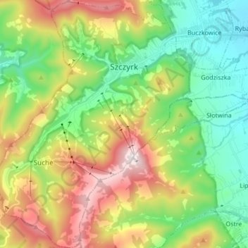
Name: Szczyrk topographic map, elevation, terrain.
Location: Szczyrk, Bielsko County, Silesian Voivodeship, 43-370, Poland (49.65280 18.95453 49.73998 19.06164)
Average elevation: 2,359 ft
Minimum elevation: 1,355 ft
Maximum elevation: 4,098 ft
Make a donation
Gear up for your next adventure:
As an Amazon Associate, this site earns from qualifying purchases at no extra cost to you.
Other topographic maps
Click on a map to view its topography, its elevation and its terrain.
Wilamowice
Poland > Silesian Voivodeship > Bielsko County > Wilamowice > Wilamowice
Average elevation: 896 ft
Pustki
Poland > Silesian Voivodeship > Bielsko County > Mazańcowice > Pustki
Average elevation: 1,027 ft