Geolocate

Bayho topographic map

Click on the map to display elevation.

About this map

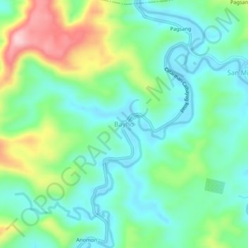
Name: Bayho topographic map, elevation, terrain.

Location: Bayho, Northern Samar, Eastern Visayas, 6403, Philippines (12.31029 124.62684 12.35029 124.66684)

Average elevation: 269 ft

Minimum elevation: 43 ft

Maximum elevation: 804 ft

Other topographic maps

Click on a map to view its topography, its elevation and its terrain.

Tarnate

Philippines > Northern Samar > San Vicente

Average elevation: 92 ft

Pambujan River

Philippines > Northern Samar

Average elevation: 180 ft

Gear up for your next adventure:

🦶Carbon Trekking Poles - Reduce knee impact on steep descents with ultra-light poles
🧤Tactile Hiking Gloves - Keep hands warm while operating GPS and smartphone screens
💧Water Purification System - Clean water on the trail with reliable purifiers
🧭Pro Hiking Compasses - High-accuracy liquid-filled compasses for topographic orientation
🏕️Tent Footprint - Protect your tent base from wear

As an Amazon Associate, this site earns from qualifying purchases at no extra cost to you.