Geolocate

Rotterode topographic map

Click on the map to display elevation.

About this map

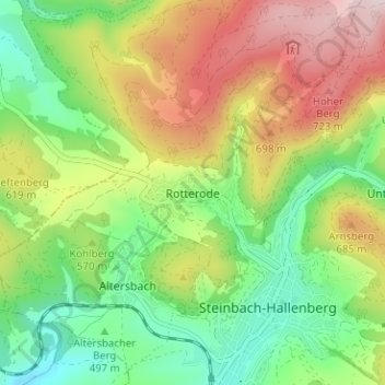
Name: Rotterode topographic map, elevation, terrain.

Location: Rotterode, Steinbach-Hallenberg, Landkreis Schmalkalden-Meiningen, Thuringia, 98587, Germany (50.69248 10.53515 50.73248 10.57515)

Average elevation: 1,870 ft

Minimum elevation: 1,280 ft

Maximum elevation: 2,713 ft

Other topographic maps

Click on a map to view its topography, its elevation and its terrain.

Gear up for your next adventure:

🌧️Backpack Rain Cover - Keep gear dry in wet weather
🪓Survival Multi‑Tool - Versatile tool for camp and trail tasks
🪑Portable Camp Table - Compact table for campsite meals
GPS Sports Watch - GPS watch for running, hiking and training
Solar GPS Watches - Advanced multisport watches with built-in topographic maps

As an Amazon Associate, this site earns from qualifying purchases at no extra cost to you.