Geolocate

Nossen topographic map

Click on the map to display elevation.

About this map

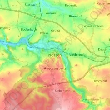
Name: Nossen topographic map, elevation, terrain.

Location: Nossen, Meißen, Saxony, 01683, Germany (51.01659 13.25807 51.09659 13.33807)

Average elevation: 896 ft

Minimum elevation: 663 ft

Maximum elevation: 1,161 ft

Gear up for your next adventure:

🪵Folding Camp Saw - Compact saw for wood and campsite work
😴Insulated Sleeping Pads - Compact and warm pads for high-elevation camping
🦟Ultrasonic Repellers - Create a bug-free zone at your camp or rest stop
🎒Hydration Pack - Hands‑free water reservoir for long hikes
📱Solar Portable Charger - Solar power bank for charging devices off‑grid

As an Amazon Associate, this site earns from qualifying purchases at no extra cost to you.