
Thank you for supporting this site ❤️
Make a donation
Make a donation
Gear up for your next adventure:
As an Amazon Associate, this site earns from qualifying purchases at no extra cost to you.
Radeberg topographic map
Click on the map to display elevation.
Thank you for supporting this site ❤️
Make a donation
Make a donation
Gear up for your next adventure:
As an Amazon Associate, this site earns from qualifying purchases at no extra cost to you.
About this map
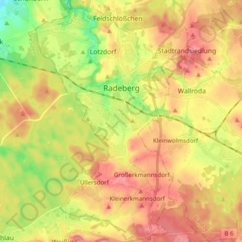
Name: Radeberg topographic map, elevation, terrain.
Location: Radeberg, Bautzen, Saxony, 01454, Germany (51.06098 13.86944 51.14586 13.95780)
Average elevation: 843 ft
Minimum elevation: 656 ft
Maximum elevation: 1,001 ft
Thank you for supporting this site ❤️
Make a donation
Make a donation
Gear up for your next adventure:
As an Amazon Associate, this site earns from qualifying purchases at no extra cost to you.
Other topographic maps
Click on a map to view its topography, its elevation and its terrain.
Koselbruch - Kózło
Germany > Saxony > Bautzen > Hoyerswerda - Wojerecy > Schwarzkollm - Čorny Chołmc
Average elevation: 436 ft