
Thank you for supporting this site ❤️
Make a donation
Make a donation
Gear up for your next adventure:
As an Amazon Associate, this site earns from qualifying purchases at no extra cost to you.
Viana do Alentejo topographic map
Click on the map to display elevation.
Thank you for supporting this site ❤️
Make a donation
Make a donation
Gear up for your next adventure:
As an Amazon Associate, this site earns from qualifying purchases at no extra cost to you.
About this map
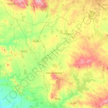
Name: Viana do Alentejo topographic map, elevation, terrain.
Location: Viana do Alentejo, Évora, Portugal (38.29953 -8.32257 38.48174 -7.90856)
Average elevation: 686 ft
Minimum elevation: 233 ft
Maximum elevation: 1,362 ft
Thank you for supporting this site ❤️
Make a donation
Make a donation
Gear up for your next adventure:
As an Amazon Associate, this site earns from qualifying purchases at no extra cost to you.
Other topographic maps
Click on a map to view its topography, its elevation and its terrain.
Montemor
Portugal > Évora > Nossa Senhora da Vila, Nossa Senhora do Bispo e Silveiras
Average elevation: 728 ft