
Make a donation
Gear up for your next adventure:
As an Amazon Associate, this site earns from qualifying purchases at no extra cost to you.
Carpathian Mountains topographic map
Click on the map to display elevation.
Make a donation
Gear up for your next adventure:
As an Amazon Associate, this site earns from qualifying purchases at no extra cost to you.
Carpathian Mountains
The northwestern Carpathians begin in Slovakia and southern Poland. They surround Transcarpathia and Transylvania in a large semicircle, sweeping towards the southeast, and end on the Danube near Orșova in Romania. The total length of the Carpathians is over 1,500 km (930 mi) and the mountain chain's width varies between 12 and 500 km (7 and 311 mi). The highest altitudes of the Carpathians occur where they are widest. The system attains its greatest breadth in the Transylvanian plateau and in the southern Tatra Mountains group – the highest range, in which Gerlachovský štít in Slovakia is the highest peak at 2,655 m (8,711 ft) above sea level. The Carpathians cover an area of 190,000 km2 (73,000 sq mi), and after the Alps, form the next-most extensive mountain system in Europe.
Make a donation
Gear up for your next adventure:
As an Amazon Associate, this site earns from qualifying purchases at no extra cost to you.
About this map
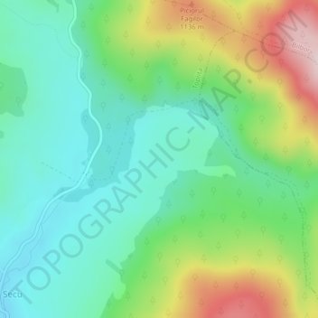
Name: Carpathian Mountains topographic map, elevation, terrain.
Location: Carpathian Mountains, Toplița, Harghita, 535705, Romania (47.00052 25.50167 47.00062 25.50177)
Average elevation: 3,215 ft
Minimum elevation: 2,844 ft
Maximum elevation: 3,999 ft
Make a donation
Gear up for your next adventure:
As an Amazon Associate, this site earns from qualifying purchases at no extra cost to you.