
Make a donation
Gear up for your next adventure:
As an Amazon Associate, this site earns from qualifying purchases at no extra cost to you.
Tunnelhill topographic map
Click on the map to display elevation.
Make a donation
Gear up for your next adventure:
As an Amazon Associate, this site earns from qualifying purchases at no extra cost to you.
Tunnelhill
Tunnelhill has the third-highest elevation among towns in Pennsylvania, at 2300 feet.
Make a donation
Gear up for your next adventure:
As an Amazon Associate, this site earns from qualifying purchases at no extra cost to you.
About this map
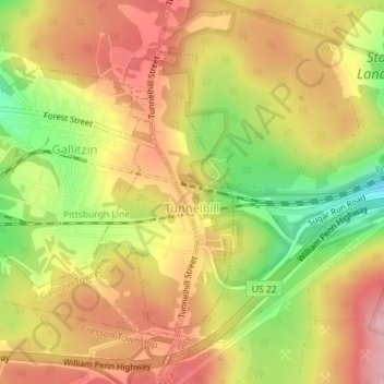
Name: Tunnelhill topographic map, elevation, terrain.
Location: Tunnelhill, Blair County, Pennsylvania, United States (40.46941 -78.54920 40.48916 -78.53703)
Average elevation: 2,274 ft
Minimum elevation: 1,988 ft
Maximum elevation: 2,477 ft
Blair County trails, hiking, mountain biking, running and outdoor activities
Make a donation
Gear up for your next adventure:
As an Amazon Associate, this site earns from qualifying purchases at no extra cost to you.
Other topographic maps
Click on a map to view its topography, its elevation and its terrain.
Beverly Hills
United States > Pennsylvania > Blair County > Logan Township
Average elevation: 1,424 ft
Yellow Spring
United States > Pennsylvania > Blair County > Catharine Township
Average elevation: 1,175 ft
Frankstown
United States > Pennsylvania > Blair County > Frankstown Township
Average elevation: 1,053 ft
Make a donation
Gear up for your next adventure:
As an Amazon Associate, this site earns from qualifying purchases at no extra cost to you.
Charlottsville
United States > Pennsylvania > Blair County > Antis Township
Average elevation: 1,148 ft