Geolocate

Bluefield topographic map

Click on the map to display elevation.

Bluefield

Bluefield is a mountain city with a warm-summer humid continental climate (Dfb) bordering on subtropical highland climate or temperate oceanic climate (Cfb), due to its elevation. It is characterized by moderately cold, snowy winters and pleasantly warm to hot summers. The normal monthly mean daily temperature ranges from 31.9 °F (−0.1 °C) in January to 70.3 °F (21.3 °C) in July; on average, there are only 2.5 days with a maximum of at least 90 °F (32 °C) or greater maxima, 1.3 days of minima at or below 0 °F (−18 °C), and 23 days where the maximum does not rise above freezing. The hottest temperature ever recorded in the city was 99 °F (37 °C), set on July 28, 1952, and August 9, 1957, with the coldest temperature at −25 °F (−32 °C), set on December 30, 1917.

Wikipedia (CC-BY-SA 3.0)

About this map

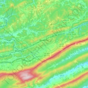
Name: Bluefield topographic map, elevation, terrain.

Location: Bluefield, Mercer County, West Virginia, 24701, United States (37.23487 -81.26545 37.29263 -81.08863)

Average elevation: 2,687 ft

Minimum elevation: 2,067 ft

Maximum elevation: 4,094 ft

Mercer County trails, hiking, mountain biking, running and outdoor activities

Other topographic maps

Click on a map to view its topography, its elevation and its terrain.

Cashers Hill

United States > West Virginia > Mercer County

Average elevation: 1,890 ft

Flipping

United States > West Virginia > Mercer County > Montcalm

Average elevation: 2,467 ft

Lake Shawnee

United States > West Virginia > Mercer County

Average elevation: 2,336 ft

Willowton

United States > West Virginia > Mercer County

Average elevation: 2,146 ft

Flat Top

United States > West Virginia > Mercer County

Average elevation: 3,156 ft

Freeman

United States > West Virginia > Mercer County > Bramwell

Average elevation: 2,500 ft

Beeson

United States > West Virginia > Mercer County

Average elevation: 2,618 ft

Rock

United States > West Virginia > Mercer County

Average elevation: 2,493 ft

Dunns

United States > West Virginia > Mercer County > Dunns

Average elevation: 2,215 ft

Gear up for your next adventure:

🥇GPS Hiking Watch - Multi‑sport GPS watch with navigation and trail tracking
🔥Camping Stove - Portable stove for camping and backcountry cooking
🧤Tactile Hiking Gloves - Keep hands warm while operating GPS and smartphone screens
🚁Photography Drones - Capture stunning aerial views of landforms and topography
Backpacking Tent - Lightweight and durable tent for multi‑day hikes

As an Amazon Associate, this site earns from qualifying purchases at no extra cost to you.