
Rock topographic map
Click on the map to display elevation.
About this map
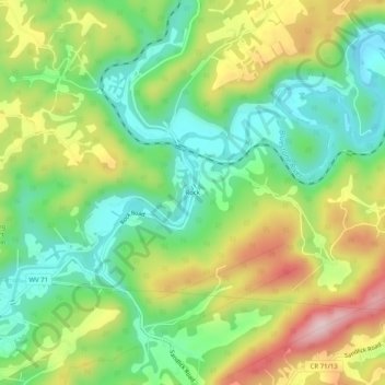
Name: Rock topographic map, elevation, terrain.
Location: Rock, Mercer County, West Virginia, 24737, United States (37.34789 -81.24204 37.38789 -81.20204)
Average elevation: 2,493 ft
Minimum elevation: 2,110 ft
Maximum elevation: 3,077 ft
Mercer County trails, hiking, mountain biking, running and outdoor activities
Other topographic maps
Click on a map to view its topography, its elevation and its terrain.
Bluefield
United States > West Virginia > Mercer County
Bluefield is a mountain city with a warm-summer humid continental climate (Dfb) bordering on subtropical highland climate or temperate oceanic climate (Cfb), due to its elevation. It is characterized by moderately cold, snowy winters and pleasantly warm to hot summers. The normal monthly mean daily temperature…
Average elevation: 2,687 ft
Princeton
United States > West Virginia > Mercer County
The average altitude of Princeton is 2400 ft, with highest points at 3100 ft and lowest points at 1700 ft, above sea level.
Average elevation: 2,497 ft
Princeton
United States > West Virginia > Mercer County
The average altitude of Princeton is 2400 ft, with highest points at 3100 ft and lowest points at 1700 ft, above sea level.
Average elevation: 2,497 ft
Bluefield
United States > West Virginia > Mercer County
Bluefield is a mountain city with a warm-summer humid continental climate (Dfb) bordering on subtropical highland climate or temperate oceanic climate (Cfb), due to its elevation. It is characterized by moderately cold, snowy winters and pleasantly warm to hot summers. The normal monthly mean daily temperature…
Average elevation: 2,687 ft