
Make a donation
Gear up for your next adventure:
As an Amazon Associate, this site earns from qualifying purchases at no extra cost to you.
Obernkirchen topographic map
Click on the map to display elevation.
Make a donation
Gear up for your next adventure:
As an Amazon Associate, this site earns from qualifying purchases at no extra cost to you.
About this map
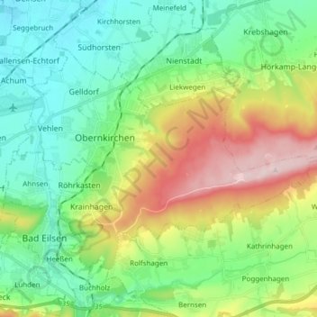
Name: Obernkirchen topographic map, elevation, terrain.
Average elevation: 502 ft
Minimum elevation: 167 ft
Maximum elevation: 1,220 ft
Make a donation
Gear up for your next adventure:
As an Amazon Associate, this site earns from qualifying purchases at no extra cost to you.
Other topographic maps
Click on a map to view its topography, its elevation and its terrain.
Escher
Deutschland > Niedersachsen > Landkreis Schaumburg
Vermutlich standen die ersten Höfe auf den höher gelegenen Flächen, während im sumpfigen Gelände entlang der Bäche erst später gesiedelt wurde. In der Erzählung „Münchhausen Pferdestall“ von G. Wiederhold reitet Borries von Münchhausen im 13. Jahrhundert durch ein „böses Stück Weg, die sumpfige Escher Heide“.
Average elevation: 669 ft