Geolocate

Bracknell topographic map

Click on the map to display elevation.

About this map
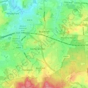
Name: Bracknell topographic map, elevation, terrain.

Location: Bracknell, Bracknell Forest, England, United Kingdom (51.38461 -0.80075 51.42944 -0.71759)

Average elevation: 262 ft

Minimum elevation: 154 ft

Maximum elevation: 427 ft

Other topographic maps

Click on a map to view its topography, its elevation and its terrain.

Nuptown

United Kingdom > England > Bracknell Forest

Average elevation: 190 ft

Cranbourne

United Kingdom > England > Bracknell Forest

Average elevation: 233 ft

Chavey Down

United Kingdom > England > Bracknell Forest

Average elevation: 253 ft

Jealott's Hill

United Kingdom > England > Bracknell Forest

Average elevation: 174 ft

Buckler's Park

United Kingdom > England > Bracknell Forest

Average elevation: 289 ft

Gear up for your next adventure:

🪵Folding Camp Saw - Compact saw for wood and campsite work
🧥Men's Rain Shells - Premium waterproof and breathable jackets for mountain weather
👖Convertible Hiking Pants - Versatile zip-off pants for changing altitudes and temperatures
🎒Outdoor Daypacks - Lightweight backpacks designed for carrying maps and essential gear
🥾Men's Hiking Boots - Durable, waterproof footwear for rugged terrain and steep inclines

As an Amazon Associate, this site earns from qualifying purchases at no extra cost to you.