Geolocate

Harleton topographic map

Click on the map to display elevation.

About this map

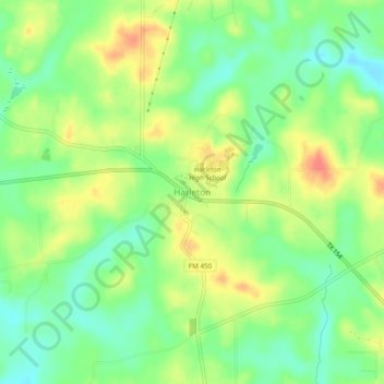
Name: Harleton topographic map, elevation, terrain.

Location: Harleton, Harrison County, Texas, 75651, United States (32.65658 -94.59398 32.69658 -94.55398)

Average elevation: 315 ft

Minimum elevation: 230 ft

Maximum elevation: 420 ft

Harrison County trails, hiking, mountain biking, running and outdoor activities

Other topographic maps

Click on a map to view its topography, its elevation and its terrain.

Waskom

United States > Texas > Harrison County

Average elevation: 272 ft

Hallsville

United States > Texas > Harrison County

Average elevation: 367 ft

Scottsville

United States > Texas > Harrison County

Average elevation: 374 ft

Nesbitt

United States > Texas > Harrison County

Average elevation: 371 ft

Gear up for your next adventure:

🧣Merino Neck Gaiters - Multi-functional headwear for wind and sun protection
🧴Hand Sanitizer - Keep hands clean while hiking
🛰️Handheld GPS Units - Professional satellite navigators for precise backcountry mapping
🗺️NatGeo Topo Maps - High-quality waterproof printed topographic maps of US Parks
🧭Map Reading Tools - Tools and kits for map navigation

As an Amazon Associate, this site earns from qualifying purchases at no extra cost to you.