Geolocate

Cale topographic map

Click on the map to display elevation.

About this map
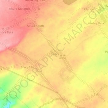
Name: Cale topographic map, elevation, terrain.

Location: Cale, Tanauan, Batangas, Calabarzon, 4232, Philippines (14.09942 121.07593 14.13942 121.11593)

Average elevation: 495 ft

Minimum elevation: 285 ft

Maximum elevation: 627 ft

Other topographic maps

Click on a map to view its topography, its elevation and its terrain.

Banjo West

Philippines > Batangas > Tanauan > Banjo Laurel

Average elevation: 509 ft

Darasa

Philippines > Batangas > Tanauan > Hidalgo

Average elevation: 568 ft

Talaga

Philippines > Batangas > Tanauan > Talaga

Average elevation: 443 ft

Darasa

Philippines > Batangas > Tanauan > Hidalgo

Average elevation: 568 ft

Maria Paz

Philippines > Batangas > Tanauan

Average elevation: 210 ft

Barangay 3

Philippines > Batangas > Tanauan > Hidalgo

Average elevation: 518 ft

Barangay 5

Philippines > Batangas > Tanauan > Hidalgo

Average elevation: 505 ft

Suplang

Philippines > Batangas > Tanauan

Average elevation: 810 ft

Ambulong

Philippines > Batangas > Tanauan > Maugat

Average elevation: 92 ft

Barangay 4

Philippines > Batangas > Tanauan

Average elevation: 466 ft

Laurel

Philippines > Batangas > Tanauan

Average elevation: 502 ft

Ulango

Philippines > Batangas > Tanauan

Average elevation: 476 ft

Bañadero

Philippines > Batangas > Tanauan > Bañadero

Average elevation: 190 ft

Barangay 5

Philippines > Batangas > Tanauan > Hidalgo

Average elevation: 505 ft

Gear up for your next adventure:

🧼Biodegradable Camping Soap - Eco‑friendly soap for outdoor hygiene
🧭Pro Hiking Compasses - High-accuracy liquid-filled compasses for topographic orientation
🛠️Backpacking Tool Kit - Essential toolkit for outdoor repairs
🧴Hand Sanitizer - Keep hands clean while hiking
🌧️Backpack Rain Cover - Keep gear dry in wet weather

As an Amazon Associate, this site earns from qualifying purchases at no extra cost to you.