
Make a donation
Gear up for your next adventure:
As an Amazon Associate, this site earns from qualifying purchases at no extra cost to you.
Schadenbach topographic map
Click on the map to display elevation.
Make a donation
Gear up for your next adventure:
As an Amazon Associate, this site earns from qualifying purchases at no extra cost to you.
About this map
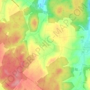
Name: Schadenbach topographic map, elevation, terrain.
Location: Schadenbach, Homberg (Ohm), Vogelsbergkreis, Hessen, Deutschland (50.67770 8.94950 50.71356 8.98917)
Average elevation: 1,066 ft
Minimum elevation: 866 ft
Maximum elevation: 1,217 ft
Make a donation
Gear up for your next adventure:
As an Amazon Associate, this site earns from qualifying purchases at no extra cost to you.
Other topographic maps
Click on a map to view its topography, its elevation and its terrain.
Maulbach
Deutschland > Hessen > Vogelsbergkreis > Homberg (Ohm) > Maulbach
Average elevation: 1,010 ft
Nieder-Ofleiden
Deutschland > Hessen > Vogelsbergkreis > Homberg (Ohm) > Nieder-Ofleiden
Average elevation: 774 ft