
Make a donation
Gear up for your next adventure:
As an Amazon Associate, this site earns from qualifying purchases at no extra cost to you.
Benito Juárez topographic map
Click on the map to display elevation.
Make a donation
Gear up for your next adventure:
As an Amazon Associate, this site earns from qualifying purchases at no extra cost to you.
About this map
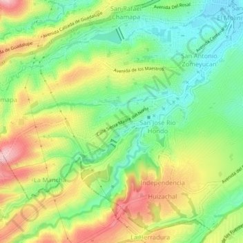
Name: Benito Juárez topographic map, elevation, terrain.
Average elevation: 7,733 ft
Minimum elevation: 7,464 ft
Maximum elevation: 8,091 ft
Make a donation
Gear up for your next adventure:
As an Amazon Associate, this site earns from qualifying purchases at no extra cost to you.
Other topographic maps
Click on a map to view its topography, its elevation and its terrain.
Río Naucalpan-Huixquilucan
México > Estado de México > Naucalpan de Juárez > Benito Juárez
Average elevation: 7,772 ft
San Lorenzo Totolinga 2a sección
México > Estado de México > Naucalpan de Juárez > San Lorenzo Totolinga
Average elevation: 7,831 ft
Make a donation
Gear up for your next adventure:
As an Amazon Associate, this site earns from qualifying purchases at no extra cost to you.
San Bartolo Naucalpan Centro
México > Estado de México > Naucalpan de Juárez
Average elevation: 7,480 ft