
马厂镇 topographic map
Interactive map
Click on the map to display elevation.
About this map
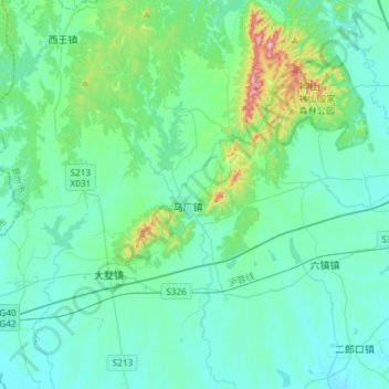
Name: 马厂镇 topographic map, elevation, terrain.
Location: 马厂镇, 全椒县, 滁州市, 安徽省, 中国 (31.94633 117.92206 32.19619 118.08598)
Average elevation: 210 ft
Minimum elevation: 33 ft
Maximum elevation: 1,227 ft
Other topographic maps
Click on a map to view its topography, its elevation and its terrain.