
Curitiba topographic map
Click on the map to display elevation.
Curitiba
The city covers 432.17 km2 (166.86 sq mi) on the First Plateau of Paraná. Curitiba has a topography of smooth, rounded hills, giving it a relatively regular shape. The city has an average altitude of 934.6 m (3,066 ft) above sea level. The highest point is to the north at 1,021 m (3,350 ft), and with lower altitudes at 864 m (2,835 ft) to the south.
About this map
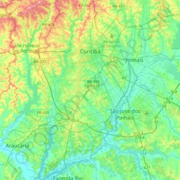
Name: Curitiba topographic map, elevation, terrain.
Location: Curitiba, Paraná, South Region, Brazil (-25.64350 -49.38914 -25.34508 -49.18432)
Average elevation: 2,992 ft
Minimum elevation: 2,818 ft
Maximum elevation: 3,478 ft
Other topographic maps
Click on a map to view its topography, its elevation and its terrain.
Curitiba
Brazil > Paraná > Região Metropolitana de Curitiba
The city covers 432.17 km2 (166.86 sq mi) on the First Plateau of Paraná. Curitiba has a topography of smooth, rounded hills, giving it a relatively regular shape. The city has an average altitude of 934.6 m (3,066 ft) above sea level. The highest point is to the north at 1,021 m (3,350 ft), and with lower…
Average elevation: 3,054 ft
Itaipu Dam
Brazil > Paraná > Foz do Iguaçu
325 metres (1,066 ft), entire dam including the 100 metres (330 ft) high Power Line 4 Pylons atop the Barrage 260 metres (850 ft), dam + the foundation inside water until the river floor 247 metres (810 ft), 196 metres (643 ft) high of roof reinforcement concrete dam + Cranes atop the Barrage 225 metres (738…
Average elevation: 630 ft
Curitiba
Brazil > Paraná > Região Metropolitana de Curitiba
The city covers 432.17 km2 (166.86 sq mi) on the First Plateau of Paraná. Curitiba has a topography of smooth, rounded hills, giving it a relatively regular shape. The city has an average altitude of 934.6 m (3,066 ft) above sea level. The highest point is to the north at 1,021 m (3,350 ft), and with lower…
Average elevation: 3,054 ft
Bosque Gutierrez
Brazil > Paraná > Região Metropolitana de Curitiba > Curitiba
Average elevation: 3,084 ft
Southern carcara
Brazil > Paraná > Região Metropolitana de Curitiba > Curitiba
Average elevation: 2,884 ft